| Original art from or about India |
| # |
Image |
Title & Artist |
Medium |
Date |
Artists |
Notes |
- |
| 01.- |
 |
18th century Map of Hindoostan from the Latest Authorities. Chiefly from the Actual Surveys made by Major James Rennell, Surveyor General to the Honourable East India Company, of the Bengal Provinces, and of the Countries Lying Between them and Dehly |
Original Hand-Colored Engraving |
1794 (Second Edition: First Edition published in 1782) |
James Rennell (born 1742, died 1830) |
Published by Laurie & Whittle, London |
Sold |
| 02.- |
 |
A Map of the North Part of Hindostan or a Geographical Survey of the Provinces of Bengal, Bahar, Awd, Ellahabad, Agra and Delhi by Major James Rennell |
Original Hand-Colored Engraving |
1794 (Second Edition: First Edition published in 1776) |
James Rennell (born 1742, died 1830) |
Published by Laurie & Whittle, London |
Sold |
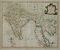
| 03.- |
 |
An Accurate Map of India by the London Geographer, George Rollos |
Original Hand-Colored Engraving |
1767 |
London Geographer, George Rollos |
Mortimer's Atlas of Trade and Commerce, London |
Sold |
| 04.- |
 |
An Original Letter from Lord Valentia to Prince Frederick, Commander-in-Chief of his Majesty's Land Forces, Congratulating him upon Wellington's Victory at the Battle of Assaye |
Original Hand Written Correspondence, and Four Original Wood Engravings |
October 19, 1803 |
Valentia, Lord George Anesley (British, 1770 - 1844) |
From the Paul F. Franco collection, New York. Franco was a major collector of Napoleonica in the early twentieth century |
|
| 05.- |
 |
Dance Of Nautch Girls by Louis Henri de Rudder after a design by Prince Alexis Dmitrievich Soltykoff |
Original Tinted Lithograph |
1859 |
Louis Henri de Rudder (French, 1807-1881)
after
Prince Alexis Dmitrievich Soltykoff (St. Petersburg, Russia, 1806 - Paris, 1859 |
'Proof Impression' printed by Auguste Bry, Paris and published by Smith, Elder & Co., London. |
Sold |
| 06.- |
 |
God Siva by the Indian artist, Arun Bose |
Original Deep Etching & Engraving |
1969 |
Arun Bose (Bangladesh, Born, 1934 - Resides, New York City) |
Signed by the artist in pencil under the lower plate-mark, Artist Proof impression. |
Sold |
| 07.- |
 |
Storming of Delhi by Thomas Sherratt designed by Matthew Somerville Morgan (M. S. Morgan) |
Original Engraving & Etching |
1859 |
Sherratt, Thomas H. (London, active, 1850 - 1865) after
Matthew Somerville Morgan (1839-1890) |
Pblished in London by the
London Printing and Publishing Company |
Sold |
| 08.- |
 |
The Romance of Rama and Sita (Illuminated Miniature Painting) by a 19th Century Indian School Artist |
Original Miniature Painting |
c. 1880 |
19th Century Indian School Artist |
Painted upon thin nineteenth century paper of Indian origin and with full margins |
Sold |
| 09.- |
 |
Two Portraits of a Royal Matrimony (Illuminated Miniature Painting) by a 19th century Northern Indian or Persian school artist |
Two Original Minature Paintings |
c. 1875 |
19th century Northern Indian or Persian school artist |
Painted on thin, nineteenth century paper of Asian origins and with full margins. Contains calligraphy on both recto and verso of the two paintings. |
|
| Selected Directories in our Gallery (Art of The Print / www.artoftheprint.com), with a focus on the area of interest for this original work of art. |
| Art of the Print / www.artoftheprint.com sells international fine art. Our collection consists of original paintings, watercolors, drawings, and original prints, such as etchings, engravings, lithographs, woodcuts, silk-screens, aquatints, mezzotints, linocuts, monoprints, and other mediums of original art. All of these works of art have been created by prominent and established painters, illustrators, watercolour artists and printmakers from around the world. The art in our gallery ranges from the early Renaissance period to the modern and contemporary art period. You can view other original artworks similar to the subject under discussion on this page listed in the following art directories. |
| Century: |
| Old Master Artist Index |
The 'Old Master' artist directory contains a selection of original works of art created by international painters, illustrators and graphic artists. These original works date from the Renaissance period to the end of the 1700's. |
| Country: |
| British Artists Index |
The 'British Art' directory contains a listing of original works of art created by artists from England, Ireland, Scotland and Wales, and or art with a British theme. The artworks date from the 17th century to the 20th century. |
| Indian Artist Index |
This directory contains a listing of original 19th & 20th century works of art with a focus on the culture and history of India. |
| Subject: |
| Maps: Art Index |
This 'Map' directory contains original 18th & 19th century works of art created by 'mapmakers' with a focus on 'Cartography - Maps' from Belgium, Germany, England, Wales, France, Italy, India and other countries. |