| Art of the Print | ||||||||
| Home | Artist Index | Gallery | Catalogue | About Us | Our Policy | Contact Us | Site Map | Search |
|
|
|||||||||||||||||||||

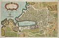
| George Rollos's "Plan of The City and Harbour of Marseille" is an original 18th century engraving printed on hand-made, laid paper and with full margins as published for Mortimer's Atlas of Trade and Commerce in London in 1767. This British plan of the City and harbour of Marseilleis a fine, original example of the late eighteenth maps designed by the Londongeographer, George Rollos. |
| Title: | Plan of The City and Harbour of Marseille (18th Century) |
| Geographer: | Rollos, George, London |
| Date: | 1767 |
| Medium: | Original Engraving |
| Source: | Mortimer's Atlas of Trade and Commerce, London |
| Note: | This map entitled, "Plan of The City and Harbour of Marseille" hails from Thomas Mortimer's "Atlas of Trade and Commerce", published in London in 1767. Many of the maps in this series were based upon the "Sieur Robert Atlas", published in Paris between 1750 and 1765. George Rollos was the London geographer responsible for adapting the maps for an English audience as well as making any necessary changes based upon new discoveries or changing political divisions. Rollos also engraved the majority of the maps, with Gibson and others engraving the remainder. Some of the larger maps were folded in order to be place in the Atlas. |
| Original maps from the eighteenth century are distinctly different from those that followed in the nineteenth and twentieth centuries. With their complex outline colourings and highly decorative cartouches, these maps can be viewed as either geographical and political histories or as beautiful works of art. One is immediately intrigued not only by the speculations on unexplored lands but by the changes in counties and territories throughout the western world. There is an ever changing story in national borders. | |
| Unfortunately, eighteenth century maps are very scarce. These were the days before lithography and steel and wood engraving -- methods, which in the nineteenth century made large editions of prints possible. A copper plate engraving, such as this original example, could yield at best about two hundred impressions before wearing down the plate. Thus these important maps are valuable not only for their age but for their rarity. | |
| Size: | 8 X 12 3/4 (Sizes in inches are approximate, height preceding width of plate-mark or image.) |
| Matted with 100% Archival Materials | |
| Condition: | This map entitled, "Plan of The City and Harbour of Marseille" is printed on eighteenth century hand-made, laid paper and with full margins as published by Mortimer in London in 1767. This is a fine, early printing with strong, hand colouring and in excellent condition throughout. It is a fine, original example of the late eighteenth century maps by the British geographer, George Rollos. |
| Price: | Sold - The price is no longer available. |
| Important Information: | The artist biographies, research and or information pertaining to all the original works of art posted on our pages has been written and designed by Greg & Connie Peters exclusively for our site, (www.artoftheprint.com). Please visit us regularly to view the latest artworks offered for sale. We will soon be posting an update of our most recent research and include the biographical and historical information pertaining to our next collection of original works of art created by artists throughout the centuries. We hope you found the information you were looking for and that it has been beneficial. Our Gallery, (Art of the Print / www.artoftheprint.com) guarantees the authenticity of every work of art we sell 100%. Full documentation and certification is provided. We offer a wide selection of international fine art dating from the early Renaissance to the contemporary art period. |
Original Engraving by the London geographer, George Rollos.
 |
| Plan of The City and Harbour of Marseille (18th Century) |
View other original engravings published for Mortimer's Atlas of Trade and Commerce.
| The 18th century London geographer, George Rollos | ||||||
| # | Image | Title & Artist | Medium | Date | Publisher | - |
| 01- |  |
An 18th Century Map of India by George Rollos | Original Hand-Colored Engraving | 1767 | Mortimer's Atlas of Trade and Commerce, London | Sold |
| 02.- |  |
An 18th Century Map of The Marquisate of Moravia By George Rollos | Original Hand-Colored Engraving | 1767 | Mortimer's Atlas of Trade and Commerce, London | |
| 03.- |  |
An 18th Century Plan of The City and Harbour of Marseille by George Rollos | Original Hand-Colored Engraving | 1767 | Mortimer's Atlas of Trade and Commerce, London | Sold |
| Selected Directories in our Gallery (Art of The Print / www.artoftheprint.com), with a focus on the area of interest for this original work of art. | |
| Art of the Print / www.artoftheprint.com sells international fine art. Our collection consists of original paintings, watercolors, drawings, and original prints, such as etchings, engravings, lithographs, woodcuts, silk-screens, aquatints, mezzotints, linocuts, monoprints, and other mediums of original art. All of these works of art have been created by prominent and established painters, illustrators, watercolour artists and printmakers from around the world. The art in our gallery ranges from the early Renaissance period to the modern and contemporary art period. You can view other original artworks similar to the subject under discussion on this page listed in the following art directories. | |
| Century: | |
| Old Master Artist Index | The 'Old Master' artist directory contains a selection of original works of art created by international painters, illustrators and graphic artists. These original works date from the Renaissance period to the end of the 1700's. |
| Country: | |
| British Artists Index | The 'British Art' directory contains a listing of original works of art created by artists from England, Ireland, Scotland and Wales, and or art with a British theme. The artworks date from the 17th century to the 20th century. |
| French Artist Index | The 'French artist' directory contains a listing of original works of art created by artists from France and or art with a French theme. The artworks date from the 17th century to the 20th century. |
| Subject: | |
| Maps: Art Index | This 'Map' directory contains original 18th & 19th century works of art created by 'mapmakers' with a focus on 'Cartography - Maps' from Belgium, Germany, England, Wales, France, Italy, India and other countries. |
![]()
Customer inquiries: Contact us ![]() or
phone Greg & Connie (905) 957-6666
or
phone Greg & Connie (905) 957-6666
www.artoftheprint.com - Home | About Us | Artist Index | Gallery | Catalogue | Our Policy | Contact Us | Site Map
| © copyrighted by Art of The Print / www.artoftheprint.com / Greg & Connie Peters. All Rights Reserved. |