
| Art of the Print | ||||||||
| Home | Artist Index | Gallery | Catalogue | About Us | Our Policy | Contact Us | Site Map | Search |
|
|
|||||||||||||||||||||

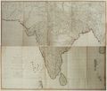
| James Rennell's original hand-coloured engraving, "A New Map of Hindoostan, of the Bengal Provinces, and of the Countries Lying Between them and Dehly" was first published in 1782. It was created chiefly from the actual surveys made by Major James Rennell, Surveyor General to the Honourable East India Company, of the Bengal Provinces, and of the Countries lying between them and Dehly: the whole exhibiting all the military roads and passes, as well as the most accurate division of the British possessions in the East Indies. The London publisher, Laurie and Whittle, created a second edition, containing several corrections and additions discovered within the previous decade. This original map hails from the 1794 second edition. It is a fine, original example of 18th century Indian cartography. |
| Title: | A New Map of Hindoostan from the Latest Authorities. Chiefly from the Actual Surveys made by Major James Rennell, Surveyor General to the Honourable East India Company, of the Bengal Provinces, and of the Countries Lying Between them and Dehly: the whole exhibiting all the Military Roads and Passes, as well as the most accurate Division of the British Possessions in the East Indies |
| Cartographer: | Rennell, James (born 1742, died 1830) |
| Date: | 1794 (Second Edition: First Edition published in 1782) |
| Medium: | Original Hand-Colored Engraving |
| Publisher: | Laurie & Whittle, London |
| Note: | “James Rennell came to Bengal in 1760. As a midshipman of 18, he arrived in time to help stop what he termed the ‘vile proceedings of the French by taking part in the capture of Pondicherry. On the outward voyage and during his long waits in Ceylon and other places, Rennell amused himself by making surveys of local bays and harbors. In 1762 he was elegible for a navy lieutenancy, but he decided that a peace treaty with the French signed in 1763 meant an end to the ambitions of young naval officers. He decided to enter the service of the East India Company. His first voyage for the Company, made before his official discharge from the navy, was to Malacca, Borneo, and islands in the Malay Archipelago. |
| His skill as a chartmaker was recognized at once, and in 1764, at 21, he was appointed to a post that was later designated surveyor-general of Bengal. ‘I was never so surprised in my life,’ he wrote. By 1765 a survey was fully underway, carried on under unique hazards; saber-blows administered while he was helping to put down a rebellion on the frontier of Bhutan partially crippled him, and in the years to come he was attacked by a maddened leopard, by fever, and by other belligerent Bhutanese. In the 1770’s he completed his survey, and went home to draw up the maps for his Bengal Atlas, published in 1779, two years after his return to London. ... | |
| In 1782 his large "Map of Hindoostan" was published. It covered most of the Indian peninsula above the Deccan. For this he relied on surveys made by other East India Company surveyors and by military engineers.” * | |
| James Rennell is widely considered to be the most important and influential map maker of eighteenth century India. His first great work, "The Bengal Atlas", came out in 1779. It contained 21 maps and plans. He also created maps of such provinces as Behar, Bengal, Delhi, Agrah, Oude and Allahabad. | |
| Perhaps his great work, however, is the map here offered for sale. "A New Map of Hindoostan" was the first approximately correct map of the whole of India. Issued upon two large sheets of folding paper measuring approximately 58” X 24” (Total: 58” X 48”) this immensely detailed map was first published in 1782. Twelve years later (1794), the London publisher, Laurie and Whittle, created a second edition, containing several corrections and additions discovered within the previous decade. This original map hails from the second edition. | |
| Reference: | * Charles Bricker, "Landmarks of Mapmaking", Thomas Crowell Company, New York, 1976. Quotation on pp. 141 & 143. |
| Size: | Two large sheets of folding paper measuring approximately 58” X 24” (Total: 58” X 48”) (Sizes in inches are approximate, height preceding width of plate-mark or image.) |
| Un Matted | |
| Condition: | Printed upon thick, eighteenth century hand-made, laid paper and with full margins as published in London in 1794. Containing folding marks, us usual. Several small tears along the folds have been restored by a previous owner. As well a previous owner has made several neat notations in 18th century fountain pen or quill along the south-eastern coast of India. The first reads, “1780, 10 Sept. Col. Baillie defeated by Hyder Alley”. This is written near the city of Madras. Further south the same individual has written, “Attacked without success by Gr. Eyre Coote, 17 June, 1781.” In all probability, this map was initially owned by a British military officer who served in India during this time. |
| Both sheets of this very map contain original hand coloring from the period and are finely printed and in very good condition throughout. "A New Map of Hindoostan" represents a most important, original example of 18th century Indian cartography. | |
| Size: | Two large sheets of folding paper measuring approximately 58” X 24” (Total: 58” X 48”) |
| Un Matted | |
| Price: | Sold - The price is no longer available. |
| Important Information: | The artist biographies, research and or information pertaining to all the original works of art posted on our pages has been written and designed by Greg & Connie Peters exclusively for our site, (www.artoftheprint.com). Please visit us regularly to view the latest artworks offered for sale. We will soon be posting an update of our most recent research and include the biographical and historical information pertaining to our next collection of original works of art created by artists throughout the centuries. We hope you found the information you were looking for and that it has been beneficial. Our Gallery, (Art of the Print / www.artoftheprint.com) guarantees the authenticity of every work of art we sell 100%. Full documentation and certification is provided. We offer a wide selection of international fine art dating from the early Renaissance to the contemporary art period. |
Original Hand-Colored Engraving by the Cartographer James Rennell.
 |
| A New Map of Hindoostan from the Latest Authorities. Chiefly from the Actual Surveys made by Major James Rennell, Surveyor General to the Honourable East India Company, of the Bengal Provinces, and of the Countries Lying Between them and Dehly: the whole exhibiting all the Military Roads and Passes, as well as the most accurate Division of the British Possessions in the East Indies |
View other Original engravings by James Rennell.
| James Rennell (born 1742, died 1830) | ||||||
| # | Image | Title & Artist | Medium | Date | Publisher | - |
| 01- |  |
18th century Map of Hindoostan from the Latest Authorities. Chiefly from the Actual Surveys made by Major James Rennell, Surveyor General to the Honourable East India Company, of the Bengal Provinces, and of the Countries Lying Between them and Dehly: | Original Hand-Colored Engraving | 1794 (Second Edition: First Edition published in 1782) | Laurie & Whittle, London | Sold |
| 02.- |  |
18th century Map of the North Part of Hindostan or a Geographical Survey of the Provinces of Bengal, Bahar, Awd, Ellahabad, Agra and Delhi by the Cartographer James Rennell. | Original Hand-Colored Engraving | 1794 (Second Edition: First Edition published in 1776) | Laurie & Whittle, London | Sold |
View other original works of art dealing with India
| Original art from or about India | |||||||
| # | Image | Title & Artist | Medium | Date | Artists | Notes | - |
| 01.- | |
18th century Map of Hindoostan from the Latest Authorities. Chiefly from the Actual Surveys made by Major James Rennell, Surveyor General to the Honourable East India Company, of the Bengal Provinces, and of the Countries Lying Between them and Dehly | Original Hand-Colored Engraving | 1794 (Second Edition: First Edition published in 1782) | James Rennell (born 1742, died 1830) | Published by Laurie & Whittle, London | Sold |
| 02.- | |
A Map of the North Part of Hindostan or a Geographical Survey of the Provinces of Bengal, Bahar, Awd, Ellahabad, Agra and Delhi by Major James Rennell | Original Hand-Colored Engraving | 1794 (Second Edition: First Edition published in 1776) | James Rennell (born 1742, died 1830) | Published by Laurie & Whittle, London | Sold |
| 03.- |  |
An Accurate Map of India by the London Geographer, George Rollos | Original Hand-Colored Engraving | 1767 | London Geographer, George Rollos | Mortimer's Atlas of Trade and Commerce, London | Sold |
| 04.- |  |
An Original Letter from Lord Valentia to Prince Frederick, Commander-in-Chief of his Majesty's Land Forces, Congratulating him upon Wellington's Victory at the Battle of Assaye | Original Hand Written Correspondence, and Four Original Wood Engravings | October 19, 1803 | Valentia, Lord George Anesley (British, 1770 - 1844) | From the Paul F. Franco collection, New York. Franco was a major collector of Napoleonica in the early twentieth century | |
| 05.- |  |
Dance Of Nautch Girls by Louis Henri de Rudder after a design by Prince Alexis Dmitrievich Soltykoff | Original Tinted Lithograph | 1859 | Louis Henri de Rudder (French, 1807-1881) after Prince Alexis Dmitrievich Soltykoff (St. Petersburg, Russia, 1806 - Paris, 1859 | 'Proof Impression' printed by Auguste Bry, Paris and published by Smith, Elder & Co., London. | Sold |
| 06.- |  |
God Siva by the Indian artist, Arun Bose | Original Deep Etching & Engraving | 1969 | Arun Bose (Bangladesh, Born, 1934 - Resides, New York City) | Signed by the artist in pencil under the lower plate-mark, Artist Proof impression. | Sold |
| 07.- |  |
Storming of Delhi by Thomas Sherratt designed by Matthew Somerville Morgan (M. S. Morgan) | Original Engraving & Etching | 1859 | Sherratt, Thomas H. (London, active, 1850 - 1865) after Matthew Somerville Morgan (1839-1890) | Pblished in London by the London Printing and Publishing Company | Sold |
| 08.- |  |
The Romance of Rama and Sita (Illuminated Miniature Painting) by a 19th Century Indian School Artist | Original Miniature Painting | c. 1880 | 19th Century Indian School Artist | Painted upon thin nineteenth century paper of Indian origin and with full margins | Sold |
| 09.- |  |
Two Portraits of a Royal Matrimony (Illuminated Miniature Painting) by a 19th century Northern Indian or Persian school artist | Two Original Minature Paintings | c. 1875 | 19th century Northern Indian or Persian school artist | Painted on thin, nineteenth century paper of Asian origins and with full margins. Contains calligraphy on both recto and verso of the two paintings. | |
| Selected Directories in our Gallery (Art of The Print / www.artoftheprint.com), with a focus on the area of interest for this original work of art. | |
| Art of the Print / www.artoftheprint.com sells international fine art. Our collection consists of original paintings, watercolors, drawings, and original prints, such as etchings, engravings, lithographs, woodcuts, silk-screens, aquatints, mezzotints, linocuts, monoprints, and other mediums of original art. All of these works of art have been created by prominent and established painters, illustrators, watercolour artists and printmakers from around the world. The art in our gallery ranges from the early Renaissance period to the modern and contemporary art period. You can view other original artworks similar to the subject under discussion on this page listed in the following art directories. | |
| Century: | |
| Old Master Artist Index | The 'Old Master' artist directory contains a selection of original works of art created by international painters, illustrators and graphic artists. These original works date from the Renaissance period to the end of the 1700's. |
| Country: | |
| British Artists Index | The 'British Art' directory contains a listing of original works of art created by artists from England, Ireland, Scotland and Wales, and or art with a British theme. The artworks date from the 17th century to the 20th century. |
| Indian Artist Index | This directory contains a listing of original 19th & 20th century works of art with a focus on the culture and history of India. |
| Subject: | |
| Maps: Art Index | This 'Map' directory contains original 18th & 19th century works of art created by 'mapmakers' with a focus on 'Cartography - Maps' from Belgium, Germany, England, Wales, France, Italy, India and other countries. |
![]()
Customer inquiries: Contact us ![]() or
phone Greg & Connie (905) 957-6666
or
phone Greg & Connie (905) 957-6666
www.artoftheprint.com - Home | About Us | Artist Index | Gallery | Catalogue | Our Policy | Contact Us | Site Map
| © copyrighted by Art of The Print / www.artoftheprint.com / Greg & Connie Peters. All Rights Reserved. |