
| Art of the Print | ||||||||
| Home | Artist Index | Gallery | Catalogue | About Us | Our Policy | Contact Us | Site Map | Search |
|
|
|||||||||||||||||||||

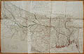
| Major James Rennell's, original engraving, "A Map of the North Part of Hindostan, Provinces of Bengal, Bahar, Awd, Ellahabad, Agra and Delhi" was first published by Dury in 1776. This original impression hails from the second edition, with up to date corrections as issued by Laurie and Whittle in London in May of 1794. This large and detailed map contains such features as Provincial Capitals, Bazaars, Fields of Battles, Forts and tides at the mouths of the Ganges. It is a geographical survey of the provinces of Bengal, Bahar, Awd, Ellahabad, Agra and Delhi. It is thus a major historical and geographical record of 18th century India and a fine original engraving by one of the greatest early cartographers of India, James Rennell. |
| Title: | A Map of the North Part of Hindostan or a Geographical Survey of the Provinces of Bengal, Bahar, Awd, Ellahabad, Agra and Delhi |
| Cartographer: | Rennell, James (born 1742, died 1830) |
| Date: | 1794 (Second Edition: First Edition published in 1776) |
| Medium: | Original Hand-Colored Engraving |
| Publisher: | Laurie & Whittle, London |
| Note: | The greatest of the early cartographers of India was James Rennell, born 1742, died 1830. ... The merit of Rennell’s work was quickly appreciated, and remained the standard for many years.” * |
| James Rennell is widely considered to be the most important and influential map maker of eighteenth century India. Rennell was appointed surveyor-general of Bengal in 1764, at the age of twenty-one. His first great work, "The Bengal Atlas", came out in 1779. It contained 21 maps and plans. He also created maps of such provinces as Behar, Bengal, Delhi, Agrah, Oude and Allahabad. | |
| "A Map of the North Part of Hindostan or a Geographical Survey of the Provinces of Bengal, Bahar, Awd, Ellahabad, Agra and Delhi" was first published by Dury in 1776. This original impression hails from the second edition, with up to date corrections and issued by Laurie and Whittle in London in May of 1794. This large and detailed map, measuring 42 1/2” X 28 1/2” inches, contains such features as Provincial Capitals, Bazaars, Fields of Battles, Forts and tides at the mouths of the Ganges. It is thus a major historical and geographical record of 18th century India. | |
| Reference: | * R. V. Tooley, "Maps and Map-Makers", Crown Publishers, New York, 1982. Quotation on p. 104. |
| Size: | 42 1/2” X 28 1/2” (Sizes in inches are approximate, height preceding width of plate-mark or image.) |
| UnMatted | |
| Condition: | Printed upon thick, eighteenth century hand-made, laid paper and with full margins as published in London in 1794. Containing folding marks, us usual. Slight paper loss exists in several of the junctions of the folds else in good condition with original hand-coloring. "A Map of the North Part of Hindostan or a Geographical Survey of the Provinces of Bengal, Bahar, Awd, Ellahabad, Agra and Delhi" represents a prime, original example of 18th century Indian cartography. |
| Price: | Sold - The price is no longer available. |
| Important Information: | The artist biographies, research and or information pertaining to all the original works of art posted on our pages has been written and designed by Greg & Connie Peters exclusively for our site, (www.artoftheprint.com). Please visit us regularly to view the latest artworks offered for sale. We will soon be posting an update of our most recent research and include the biographical and historical information pertaining to our next collection of original works of art created by artists throughout the centuries. We hope you found the information you were looking for and that it has been beneficial. Our Gallery, (Art of the Print / www.artoftheprint.com) guarantees the authenticity of every work of art we sell 100%. Full documentation and certification is provided. We offer a wide selection of international fine art dating from the early Renaissance to the contemporary art period. |
Original Hand-Colored Engraving by the Cartographer James Rennell.
 |
| A Map of the North Part of Hindostan or a Geographical Survey of the Provinces of Bengal, Bahar, Awd, Ellahabad, Agra and Delhi |
View other Original engravings by James Rennell.
| James Rennell (born 1742, died 1830) | ||||||
| # | Image | Title & Artist | Medium | Date | Publisher | - |
| 01- |  |
18th century Map of Hindoostan from the Latest Authorities. Chiefly from the Actual Surveys made by Major James Rennell, Surveyor General to the Honourable East India Company, of the Bengal Provinces, and of the Countries Lying Between them and Dehly: | Original Hand-Colored Engraving | 1794 (Second Edition: First Edition published in 1782) | Laurie & Whittle, London | Sold |
| 02.- |  |
18th century Map of the North Part of Hindostan or a Geographical Survey of the Provinces of Bengal, Bahar, Awd, Ellahabad, Agra and Delhi by the Cartographer James Rennell. | Original Hand-Colored Engraving | 1794 (Second Edition: First Edition published in 1776) | Laurie & Whittle, London | Sold |
View other original works of art dealing with India
| Original art from or about India | |||||||
| # | Image | Title & Artist | Medium | Date | Artists | Notes | - |
| 01.- | |
18th century Map of Hindoostan from the Latest Authorities. Chiefly from the Actual Surveys made by Major James Rennell, Surveyor General to the Honourable East India Company, of the Bengal Provinces, and of the Countries Lying Between them and Dehly | Original Hand-Colored Engraving | 1794 (Second Edition: First Edition published in 1782) | James Rennell (born 1742, died 1830) | Published by Laurie & Whittle, London | Sold |
| 02.- | |
A Map of the North Part of Hindostan or a Geographical Survey of the Provinces of Bengal, Bahar, Awd, Ellahabad, Agra and Delhi by Major James Rennell | Original Hand-Colored Engraving | 1794 (Second Edition: First Edition published in 1776) | James Rennell (born 1742, died 1830) | Published by Laurie & Whittle, London | Sold |
| 03.- |  |
An Accurate Map of India by the London Geographer, George Rollos | Original Hand-Colored Engraving | 1767 | London Geographer, George Rollos | Mortimer's Atlas of Trade and Commerce, London | Sold |
| 04.- |  |
An Original Letter from Lord Valentia to Prince Frederick, Commander-in-Chief of his Majesty's Land Forces, Congratulating him upon Wellington's Victory at the Battle of Assaye | Original Hand Written Correspondence, and Four Original Wood Engravings | October 19, 1803 | Valentia, Lord George Anesley (British, 1770 - 1844) | From the Paul F. Franco collection, New York. Franco was a major collector of Napoleonica in the early twentieth century | |
| 05.- |  |
Dance Of Nautch Girls by Louis Henri de Rudder after a design by Prince Alexis Dmitrievich Soltykoff | Original Tinted Lithograph | 1859 | Louis Henri de Rudder (French, 1807-1881) after Prince Alexis Dmitrievich Soltykoff (St. Petersburg, Russia, 1806 - Paris, 1859 | 'Proof Impression' printed by Auguste Bry, Paris and published by Smith, Elder & Co., London. | Sold |
| 06.- |  |
God Siva by the Indian artist, Arun Bose | Original Deep Etching & Engraving | 1969 | Arun Bose (Bangladesh, Born, 1934 - Resides, New York City) | Signed by the artist in pencil under the lower plate-mark, Artist Proof impression. | Sold |
| 07.- |  |
Storming of Delhi by Thomas Sherratt designed by Matthew Somerville Morgan (M. S. Morgan) | Original Engraving & Etching | 1859 | Sherratt, Thomas H. (London, active, 1850 - 1865) after Matthew Somerville Morgan (1839-1890) | Pblished in London by the London Printing and Publishing Company | Sold |
| 08.- |  |
The Romance of Rama and Sita (Illuminated Miniature Painting) by a 19th Century Indian School Artist | Original Miniature Painting | c. 1880 | 19th Century Indian School Artist | Painted upon thin nineteenth century paper of Indian origin and with full margins | Sold |
| 09.- |  |
Two Portraits of a Royal Matrimony (Illuminated Miniature Painting) by a 19th century Northern Indian or Persian school artist | Two Original Minature Paintings | c. 1875 | 19th century Northern Indian or Persian school artist | Painted on thin, nineteenth century paper of Asian origins and with full margins. Contains calligraphy on both recto and verso of the two paintings. | |
| Selected Directories in our Gallery (Art of The Print / www.artoftheprint.com), with a focus on the area of interest for this original work of art. | |
| Art of the Print / www.artoftheprint.com sells international fine art. Our collection consists of original paintings, watercolors, drawings, and original prints, such as etchings, engravings, lithographs, woodcuts, silk-screens, aquatints, mezzotints, linocuts, monoprints, and other mediums of original art. All of these works of art have been created by prominent and established painters, illustrators, watercolour artists and printmakers from around the world. The art in our gallery ranges from the early Renaissance period to the modern and contemporary art period. You can view other original artworks similar to the subject under discussion on this page listed in the following art directories. | |
| Century: | |
| Old Master Artist Index | The 'Old Master' artist directory contains a selection of original works of art created by international painters, illustrators and graphic artists. These original works date from the Renaissance period to the end of the 1700's. |
| Country: | |
| British Artists Index | The 'British Art' directory contains a listing of original works of art created by artists from England, Ireland, Scotland and Wales, and or art with a British theme. The artworks date from the 17th century to the 20th century. |
| Indian Artist Index | This directory contains a listing of original 19th & 20th century works of art with a focus on the culture and history of India. |
| Subject: | |
| Maps: Art Index | This 'Map' directory contains original 18th & 19th century works of art created by 'mapmakers' with a focus on 'Cartography - Maps' from Belgium, Germany, England, Wales, France, Italy, India and other countries. |
![]()
Customer inquiries: Contact us ![]() or
phone Greg & Connie (905) 957-6666
or
phone Greg & Connie (905) 957-6666
www.artoftheprint.com - Home | About Us | Artist Index | Gallery | Catalogue | Our Policy | Contact Us | Site Map
| © copyrighted by Art of The Print / www.artoftheprint.com / Greg & Connie Peters. All Rights Reserved. |