
| Art of the Print | ||||||||
| Home | Artist Index | Gallery | Catalogue | About Us | Our Policy | Contact Us | Site Map | Search |
|
|
|||||||||||||||||||||

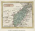
| John Seller's 18th century map, "Northamptonshire" is an original engraving published in 1787 for Francis Grose "The Antiquities of England and Wales". The borders surrounding this map of Northamptonshire show parts of Lincoln, Rutland, Leicewster Shire, Warwick Shire, Oxford, Buckingham Shire, Bedford Shire and Huntington Shire. Francis Grose states that Northamptonshre is an inland county, near the centre of South Britain, that under the ancient Britons belonged to their principality of the Coritani. This eighteenth century English county map of Northamptonshire stands as a fine, original example of early British cartography and the art of John Seller. |
| Title: | 18th Century Map of Northamptonshire |
| Artist: | Seller, John (London, 1639 - 1701) |
| Date: | 1695 (Grose edition, 1787) |
| Medium: | Original Engraving |
| Publisher: | Francis Grose, London |
| Note: | John Seller (London, 1639 - 1701) had an active life. He was the Royal Hydrographer and mathematical instrument maker to King Charles II and James II. John Seller was also a major British publisher of maps, charts and geographical and nautical publications. Such fine series of maps as, "Atlas Minimus" (1679), "New System of Geography" (1685), "Atlas Terrestris" (1680-1685), and "The English Pilot" were developed by his hand. |
| This original map of Northamptonshire hails from John Seller's most famous series of English maps, the "Anglia Contracta". First printed in 1695, the set consisted of sixty-two miniature maps of the countries of England and Wales. John Seller's aim was to create attractive and accurate maps on a scale which the traveller could easily refer to., They have long been praised as among the best miniature maps ever made. The borders surrounding this map of Northamptonshire show parts of Lincoln, Rutland, Leicewster Shire, Warwick Shire, Oxford, Buckingham Shire, Bedford Shire and Huntington Shire. | |
| This original engraving entitled, "Northamptonshire" originates from the Francis Grose edition of 1787, and was published with his lengthy, "The Antiquities of England and Wales". In total, editions of the "Anglia Contracta" maps were printed in 1695, 1696, 1703, 1787, and 1801. As English county maps did not require revisions do to new discoveries, virtually all maps were reissued in various editions. John Speed's great county maps, for example, went through more than twelve editions from 1611 to 1770. Nevertheless, one should keep in mind that these early maps by John Seller and his contemporaries are very scarce. At this time, the engraved copper plates could yield no more than three to four hundred impressions before the lines would all but disintegrate. | |
| Edition: | Grose edition published in 1787 |
| Source: | Anglia Contracta (Francis Grose Esq. Edition, 1787) "The Antiquities of England and Wales" |
| English County Map | |
| Size: | 5 X 6 (Sizes in inches are approximate, height preceding width of plate-mark or image.) |
| Matted with 100% Archival Materials | |
| Buy Now | Price: $165.00 US |
| Condition: | Printed on 18th century hand-made, laid paper and with full margins as published by Francis Grose in London in 1787. This original engraving is a fine impression and in good condition throughout. Altogether, Altogether, this original engraved eighteenth century English county map of Northamptonshire stands as a prime example of early English cartography and the art of John Seller. |
| Important Information: | The artist biographies, research and or information pertaining to all the original works of art posted on our pages has been written and designed by Greg & Connie Peters exclusively for our site, (www.artoftheprint.com). Please visit us regularly to view the latest artworks offered for sale. We will soon be posting an update of our most recent research and include the biographical and historical information pertaining to our next collection of original works of art created by artists throughout the centuries. We hope you found the information you were looking for and that it has been beneficial. Our Gallery, (Art of the Print / www.artoftheprint.com) guarantees the authenticity of every work of art we sell 100%. Full documentation and certification is provided. We offer a wide selection of international fine art dating from the early Renaissance to the contemporary art period. |
Original Engraving by the British Cartagropher, John Seller.
 |
| 18th Century Map of Northamptonshire |
View other original engravings by John Seller
published by Francis Gross for "The Antiquities of England and Wales".
| "The Antiquities of England and Wales", John Seller (London, 1639 - 1701) |
||||
| # | Image | Title | Medium | Date |
| 01.- |  |
18th Century Map of Angelsea Island by John Seller | Original Engraving | 1695 (Grose edition, 1787) |
| 02.- |  |
18th Century Map of Brecknock Shire by John Seller | Original Engraving | 1695 (Grose edition, 1787) |
| 03.- |  |
18th Century Map of Caermarthen Shire by John Seller | Original Engraving | 1695 (Grose edition, 1787) |
| 04.- |  |
18th Century Map of Caernarvonshire by John Seller | Original Engraving | 1695 (Grose edition, 1787) |
| 05.- |  |
18th Century Map of Cardinganshire by John Seller | Original Engraving | 1695 (Grose edition, 1787) |
| 06.- |  |
18th Century Map of Flintshire by John Seller | Original Engraving | 1695 (Grose edition, 1787) |
| 07.- |  |
18th Century Map of Herefordshire by John Seller | Original Engraving | 1695 (Grose edition, 1787) |
| 08.- |  |
18th Century Map of Montgomery Shire by John Seller | Original Engraving | 1695 (Grose edition, 1787) |
| 09.- |  |
18th Century Map of Northamptonshire by John Seller | Original Engraving | 1695 (Grose edition, 1787) |
| 10.- |  |
18th Century Map of Northumberland by John Seller | Original Engraving | 1695 (Grose edition, 1787) |
| 11.- |  |
18th Century Map of Suffolk by John Seller | Original Engraving | 1695 (Grose edition, 1787) |
| Selected Directories in our Gallery (Art of The Print / www.artoftheprint.com), with a focus on the area of interest for this original work of art. | |
| Art of the Print / www.artoftheprint.com sells international fine art. Our collection consists of original paintings, watercolors, drawings, and original prints, such as etchings, engravings, lithographs, woodcuts, silk-screens, aquatints, mezzotints, linocuts, monoprints, and other mediums of original art. All of these works of art have been created by prominent and established painters, illustrators, watercolour artists and printmakers from around the world. The art in our gallery ranges from the early Renaissance period to the modern and contemporary art period. You can view other original artworks similar to the subject under discussion on this page listed in the following art directories. | |
| Century: | |
| Old Master Artist Index | The 'Old Master' artist directory contains a selection of original works of art created by international painters, illustrators and graphic artists. These original works date from the Renaissance period to the end of the 1700's. |
| Country: | |
| British Artists Index | The 'British Art' directory contains a listing of original works of art created by artists from England, Ireland, Scotland and Wales, and or art with a British theme. The artworks date from the 17th century to the 20th century. |
| Subject: | |
| Maps: Art Index | This 'Map' directory contains original 18th & 19th century works of art created by 'mapmakers' with a focus on 'Cartography - Maps' from Belgium, Germany, England, Wales, France, Italy, India and other countries. |
![]()
Customer inquiries: Contact us ![]() or
phone Greg & Connie (905) 957-6666
or
phone Greg & Connie (905) 957-6666
www.artoftheprint.com - Home | About Us | Artist Index | Gallery | Catalogue | Our Policy | Contact Us | Site Map
| © copyrighted by Art of The Print / www.artoftheprint.com / Greg & Connie Peters. All Rights Reserved. |