| Title: |
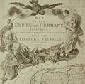
18th Century Map of the Empire of Germany Including all the States Comprehended under that Name: With the Kingdom of Prussia, Etc. |
| Engraver: |
Kitchin, Thomas (London, c. 1710 - 1779) |
| Designer: |
Louis De La Rochette |
| Date: |
1794 |
| Medium: |
Original Hand - Coloured Engraving |
| Publisher: |
Laurie & Whittle, Fleet Street, London |
| Note: |
Thomas Kitchin: One of England's most productive mapmakers of the last
half of the eighteenth century, Thomas Kitchin both engraved and published
most of his own work. And from his premises at the Sign of the Star, situated
at Holborn Hill, he also sold artists' materials and wrote and published
books of instruction of the various mediums of artistic expression, such
as oil painting, watercolour composition, and engraving and etching. |
| |
Robert Laurie, or Lawrie, (1755-1836) and James Whittle (1757-1818)
were major British publishers and printsellers during the late eighteenth
and early nineteenth centuries. Initially Robert Laurie developed his reputation
as a mezzotint engraver of caricatures, portraits, sporting subjects and
topographical views, both after the old masters and his contemporaries.
In fact, in 1776, he was awarded a premium from the Society of Arts for
inventing a new method of printing mezzotints in colours. Around 1790,
Laurie and Whittle took control of the publishing house of Robert Sayer
at the Golden Buck in Fleet Street. Their firm published prints ranging
from satirical works to topographical views, but they quickly became best
known for their large, accurate maps and atlases. In 1812 Robert Laurie
retired and was succeeded by his son, Richard Holmes Laurie. |
| |
This very large map of Germany was published in 1794 in London
by Laurie and Whittle. It was printed on two adjoining sheets of eighteenth
century, laid paper, each measuring 20 1/2 X 48 inches, for a combined
total of 41 X 48 inches. This map represents a re-issue of Kitchin,s
1785 map of Germany, published in London by Bowles & Carver. Besides
the remarkable detail of this map, other notable features include a very
large cartouche crowned by the two headed eagle of Germany and a Scale
of Degrees that includes the Common miles of England and Italy, Great miles
of Germany and Bohemia, Common miles of Germany, and Leagues of Germany,
Bohemia, Switzerland, France, Silesia and Austria. |
| Size: |
20 1/2 X 48 for each engraving for a combined measurement of 41 X 48 (Sizes in inches are approximate,
height preceding width of plate-mark or image.) |
| |
UnMatted |
| Buy Now |
Price: $895.00 US |
| Condition: |
Printed upon two sheets of thick, eighteenth century hand-made,
laid paper and with full margins as published by Laurie and Whittle in
London in 1794. Containing the vertical folding marks, as usual. Bearing
minor, marginal tears (not within the actual map) as well as two small
spots of staining within the lower map, else a fine early impression
and in very good condition throughout. This large, very detailed map of the
Empire of Germany Including all the States Comprehended under that Name:
With the Kingdom of Prussia, Etc. represents a very important, original example
of eighteenth century cartography. |
| Important Information: |
The artist biographies, research and or information pertaining to all the original works of art posted on our pages has been written and designed by Greg & Connie Peters exclusively for our site, (www.artoftheprint.com). Please visit us regularly to view the latest artworks offered for sale. We will soon be posting an update of our most recent research and include the biographical and historical information pertaining to our next collection of original works of art created by artists throughout the centuries. We hope you found the information you were looking for and that it has been beneficial.
Our Gallery, (Art of the Print / www.artoftheprint.com) guarantees the authenticity of every work of art we sell 100%. Full documentation and certification is provided. We offer a wide selection of international fine art dating from the early Renaissance to the contemporary art period. |