| Title: |
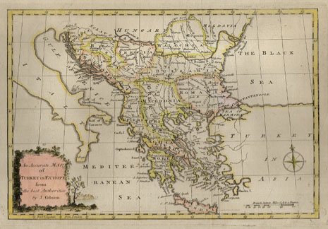
An Accurate Map of Turkey in Europe |
| Engraver: |
Gibson, John (British, active, 18th century) |
| Date: |
1767 |
| Medium: |
Original Hand-Coloured Engraving |
| Source: |
Mortimer's Atlas of Trade and Commerce, London |
| Note: |
Original maps from the eighteenth century are markedly
different from those that followed in the nineteenth century. With their
complex outline colourings and highly decorative cartouches, these earlier
maps can be viewed either as beautiful works of art or as geographical
and political histories. One is immediately intrigued by the shifting
lines of territories and countries. There is an ever changing story in
national borders. |
| |
Unfortunately, eighteenth century maps are very scarce.
These were the days before steel and wood engraving or lithography processes
which permitted large editions of prints in the following century. A
copper plate engraving, such as this original example, could yield at
best about two hundred impressions before wearing down completely. Thus
these important maps are valuable not only for their age but for their
rarity. |
| |
This map entitled, An Accurate Map of Turkey in Europe
hails from Thomas Mortimer's Atlas of Trade
and Commerce, published in London in 1767. Many of the maps in this set
were based upon the Sieur Robert Atlas, published in Paris between 1750
and 1765. George Rollos was the London geographer responsible for adapting
the maps for an English audience as well as making any necessary changes
based upon new discoveries or shifting political divisions. George Rollos also
engraved some of the maps, but the majority were engraved by John Gibson.
Both single page and double page folded maps were included in the Atlas. |
| Size: |
7 3/4 X 11 1/2 (Sizes in inches are approximate,
height preceding width of plate-mark or image.) |
| |
Matted with 100% Archival Materials |
| Condition: |
Printed on eighteenth century hand-made, laid paper and
with full margins as published by Mortimer in London in 1767. A fine,
early printing and in excellent condition throughout. Altogether this
beautiful engraved map stands as a splendid example of the art of eighteenth
century cartography. |
| Price: |
Sold - The price is no longer available. |
| Important Information: |
The artist biographies, research and or information pertaining to all the original works of art posted on our pages has been written and designed by Greg & Connie Peters exclusively for our site, (www.artoftheprint.com). Please visit us regularly to view the latest artworks offered for sale. We will soon be posting an update of our most recent research and include the biographical and historical information pertaining to our next collection of original works of art created by artists throughout the centuries. We hope you found the information you were looking for and that it has been beneficial.
Our Gallery, (Art of the Print / www.artoftheprint.com) guarantees the authenticity of every work of art we sell 100%. Full documentation and certification is provided. We offer a wide selection of international fine art dating from the early Renaissance to the contemporary art period. |