| Title: |
Division Astronomique de la Terre (Astronomical Division of the Earth) |
| Pubishers: |
Louis Charles Desnos & Claude Buy de Mornas, Paris |
| Date: |
1761 |
| Medium: |
Original Hand-Colored Engraving |
| Source: |
Atlas Methodique et Elementaire de Geographie et d'Histoire |
| Note: |
Louis Charles Desnos and Claude Buy de Mornas: During
the second half of the eighteenth century Paris became the map making
center of the world. Two of its most important contributors were L. C.
Desnos and Claude Buy de Mornas. Louis-Charles Desnos (France, 1725 - 1805) was
both a globe maker and publisher of maps. In the former capacity he was
appointed globe maker to the King of Denmark but spent most of his life
working in Paris. Besides this map, which was published in "Atlas Methodique
et Elementaire", L.C. Desnos also published the maps for "Routes des Postes"
(1761), "Nouvel Atlas d'Angleterre" (1767) and "Atlas General" (1786). |
| |
Claude Buy de Mornas (died, 1783) was both the publisher
and author of the text for "Atlas Methodique et Elementaire". He also served
as Geographer to King Louis XVI and the Duc de Berry. Both Louis-Charles
Desnos and Claude Buy de Mornas ran their Paris establishments from the
Rue St. Jacques. |
| |
In general these decorative, double-page maps dealt with
a wide range of subjects such as, the Sun, the stars, the solar system,
eclipses, seasons, climates and both terrestrial and celestial coordinates.
Each map contains a central image with flanking columns of text and elaborate
borders framing all. The hand-coloring dates from the time of publication. |
| |
These original engraved maps are important not only for
the subject each represents, but they also demonstrate how strongly the
disciplines of geography and astronomy were allied in the eighteenth
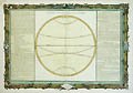
century. "Division Astronomique de la Terre" deals specifically
with the lines, points and circles of the Earth. Included are the Arctic and
Antarctic poles and circles, the tropics of Cancer and Capricorn, the Equator,
the Meridian and the line of the Sun's Ecliptic ("Eclyptique")
Explanatory text is found on the side columns. England's National Maritime Museum includes seventeen examples
of these L. C. Desnos and Buy de Mornas maps in its permanent collection.
They can be seen at their web site, www.nmm.ac.uk. Below is a closup
of the central image for "Division Astronomique de la Terre"
(Astronomical Division of the Earth). |
| |
 |
| Size: |
14 1/2 X 20 3/4 (Sizes in inches are approximate,
height preceding width of plate-mark or image.) |
| |
UnMatted |
| Buy Now |
Price: $465.00 US |
| Condition: |
Printed upon thick, hand-made, laid paper and with full
margins as published in Paris in 1761. Containing slight water staining
in the upper left corner (well removed from the actual image), else a
strongly printed impression with fine, unfaded colors and in excellent
condition throughout. Containing the double-page vertical fold, as always.
Altogether "Division Astronomique de la Terre" (Astronomical Division of
the Earth) represents a prime original example of the 18th century map
making skills of Claude Buy de Mornas and Louis-Charles Desnos. |
| Subject: |
Claude Buy de Mornas and Louis-Charles Desnos, Division
"Astronomique de la Terre" (Astronomical Division of the Earth), Atlas
Methodique et Elementaire, lines, points and circles of the Earth, Arctic
and Antarctic poles and circles, the tropics of Cancer and Capricorn,
the Equator, the Meridian and the line of the Sun's Ecliptic, a globe
maker and publisher of maps, eighteenth century Paris map making. |
| Important Information: |
The artist biographies, research and or information pertaining to all the original works of art posted on our pages has been written and designed by Greg & Connie Peters exclusively for our site, (www.artoftheprint.com). Please visit us regularly to view the latest artworks offered for sale. We will soon be posting an update of our most recent research and include the biographical and historical information pertaining to our next collection of original works of art created by artists throughout the centuries. We hope you found the information you were looking for and that it has been beneficial.
Our Gallery, (Art of the Print / www.artoftheprint.com) guarantees the authenticity of every work of art we sell 100%. Full documentation and certification is provided. We offer a wide selection of international fine art dating from the early Renaissance to the contemporary art period. |