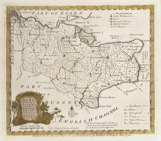
Art of The Print Logo for www.artoftheprint.com
www.artoftheprint.com
Art of the Print
Home Artist Index Gallery Catalogue About Us Our Policy Contact Us Site Map Search

Emanuel Bowen

Emanuel Bowen - 18th Century Map of Kent

18th Century Map of Kent

Emanuel Bowen's 18th Century map of Kent is an original engraving printed upon eighteenth century, hand-made, laid paper and with full margins as published in London by W. Owen in 1756 for the General Magazine of Arts and Sciences. This English county map depicts the Burroughs & Market Towns within Kent. This 18th century map includes part of Essex and Part of Sussex, Sutton, Aylesford, Shepway, Augustine, Maidstone, Canterbury, Rochester, and other places of interest. It is an important example of 18th Century English maps and the famous cartography by the British artist, Emanuel Bowen.
 
Title: 18th Century Map of Kent
Artist: Bowen, Emanuel (Clerkenwell, c. 1698 - 1767)
Date: 1756
Medium: Original Engraving
Publisher: W. Owen, Temple Bar, London
Source: General Magazine of Arts & Sciences " Divided into its Hundreds, Containing all the Burroughs & Market Towns".
Note: Emanuel Bowen: There is no doubt that Emanuel Bowen is one of England's greatest eighteenth century mapmakers. His famous world atlasas include, A complete system of Georgrpahy (1744 - 1747) and A complete Atlas or District View of the Known World (1752). Bowen was also commissioned to supply the maps for Harris's Voyages (1744) and for the Universal History of the World. Yet Emanuel Bowen's greatest achievement is surely his series of English county maps. Together with Thomas Kitchin, he produced the spectacular large county maps for the large English Atlas (1755) and The Royal English Atlas (1762). As well, between 1756 and 1763, Emanuel Bowen created forty smaller county maps for William Owen's General Magazine of Arts and Sciences. This original map of Kent hails from the last named publication.
  Emanuel Bowen's smaller county maps are in no manner inferior to his larger productions. As one can see, The detailing is remarkable, with hundreds of lathes of each county clearly delineated, as well as all the towns, forests and roads and their distances. Such superb work as this earned for Emanuel Bowen the unusual distinction of being appointed engraver of maps to both England's George II and France's Louis XV. Alas, Emanuel Bowen's meticulous work had its price: he went practically blind and ended his days in poverty.
  The cartouche on this 18th century map of Kent reads; "Kent divided into its lathes, containing the city burrough and market towns, with the roads and distances by Emanuel Bowen Geographer to his Majesty." The Map itself depicts part of Essex and Part of Sussex, Sutton, Aylesford, Shepway, Augustine, Maidstone, Canterbury, Rochester, and other places of interest within this area.
Size: 7 1/4 X 8 1/4 (Sizes in inches are approximate, height preceding width of plate-mark or image.)
  Matted with 100% Archival Materials
Buy Now Price: $245.00 US
Condition: Printed upon 18th Century, hand-made, laid paper and with full margins as published in London by Owen on the above date. It is a superb, early impression and in excellent condition throughout. This original Map of Kent represents an important example of the famous cartography of Emanuel Bowen.
Important Information:

The artist biographies, research and or information pertaining to all the original works of art posted on our pages has been written and designed by Greg & Connie Peters exclusively for our site, (www.artoftheprint.com). Please visit us regularly to view the latest artworks offered for sale. We will soon be posting an update of our most recent research and include the biographical and historical information pertaining to our next collection of original works of art created by artists throughout the centuries. We hope you found the information you were looking for and that it has been beneficial.

Our Gallery, (Art of the Print / www.artoftheprint.com) guarantees the authenticity of every work of art we sell 100%. Full documentation and certification is provided. We offer a wide selection of international fine art dating from the early Renaissance to the contemporary art period.

Original Engraving by the British cartographer, Emanuel Bowen

18th Century Map of Kent Original Engraving by the British cartographer Emanuel Bowen
18th Century Map of Kent

View other original engraved maps by Emanuel Bowen

Emanuel Bowen (Clerkenwell, c. 1698 - 1767)
# Image Title & Artist Medium Date Publisher
01- 18th Century Map of Berkshire by Emanuel Bowen 18th Century Map of Berkshire by Emanuel Bowen Original Engraving 1758 W. Owen, Temple Bar, London
02.- 18th Century Map of Cheshire by Emanuel Bowen 18th Century Map of Cheshire by Emanuel Bowen Original Engraving 1761 W. Owen, Temple Bar, London
03.- 18th Century Map of Berkshire by Emanuel Bowen 18th Century Map of Devonshire by Emanuel Bowen Original Engraving 1761 W. Owen, Temple Bar, London
04.- 18th Century Map of Devonshire by Emanuel Bowen 18th Century Map of Dorset by Emanuel Bowen Original Engraving 1762 W. Owen, Temple Bar, London
05.- 18th Century Map of Kent by Emanuel Bowen 18th Century Map of Kent by Emanuel Bowen Original Engraving 1756 W. Owen, Temple Bar, London

Selected Directories in our Gallery (Art of The Print / www.artoftheprint.com), with a focus on the area of interest for this original work of art.
Art of the Print / www.artoftheprint.com sells international fine art. Our collection consists of original paintings, watercolors, drawings, and original prints, such as etchings, engravings, lithographs, woodcuts, silk-screens, aquatints, mezzotints, linocuts, monoprints, and other mediums of original art. All of these works of art have been created by prominent and established painters, illustrators, watercolour artists and printmakers from around the world. The art in our gallery ranges from the early Renaissance period to the modern and contemporary art period. You can view other original artworks similar to the subject under discussion on this page listed in the following art directories.
Century:
Old Master Artist Index The 'Old Master' artist directory contains a selection of original works of art created by international painters, illustrators and graphic artists. These original works date from the Renaissance period to the end of the 1700's.
Country:
British Artists Index The 'British Art' directory contains a listing of original works of art created by artists from England, Ireland, Scotland and Wales, and or art with a British theme. The artworks date from the 17th century to the 20th century.
Subject:
Maps: Art Index This 'Map' directory contains original 18th & 19th century works of art created by 'mapmakers' with a focus on 'Cartography - Maps' from Belgium, Germany, England, Wales, France, Italy, India and other countries.


www.artoftheprint.com - Art of The Print Gallery

Customer inquiries: Contact us E-mail Address for www.artoftheprint.com or phone Greg & Connie (905) 957-6666

www.artoftheprint.com - Home | About Us | Artist Index | Gallery | Catalogue | Our Policy | Contact Us | Site Map

© copyrighted by Art of The Print / www.artoftheprint.com / Greg & Connie Peters. All Rights Reserved.