| Title: |
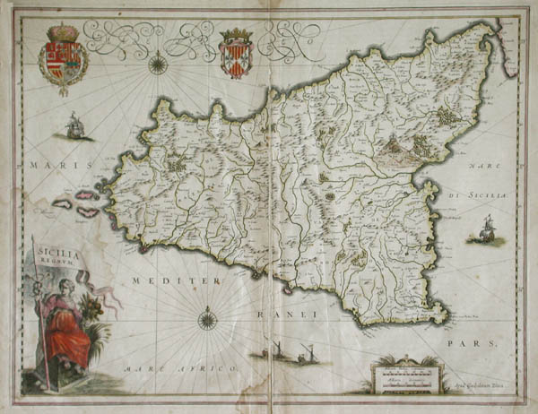
Sicilia Regnum (Map of the Kingdom of Sicily) |
| Artist: |
Blaeu, Willem Janszoon (Alkmaar, 1571 - Amsterdam,
1638) |
| Date: |
1635 |
| Medium: |
Original Hand-Coloured Engraving |
| Publisher: |
Willem Blaeu |
| Source: |
Theatrum Orbis Terrarum |
| Note: |
Willem Janszoon Blaeu 'Willem Blaeu': The greatest of all early seventeenth century map-makers, Willem Blaeu spent two years studying cartography under the Danish astronomer, Tycho Brahe. Willem Blaeu began to make globes, maps and navigational instruments in Amsterdam in 1596. During the following years the firm of Blaeu produced remarkable sets of maps dealing with all fields of cartographic investigation. Some of the more noteworthy achievements are, "Terrestrial and Celestial Globes" (1599), "Sea Atlas" (1608), "World Atlas" (1630) and "General Atlas of Towns" (1644). |
| |
Until 1617 Willem Blaeu signed his maps Guilielmus Janssonius or Willems Jans Zoon. After that date his maps bear the appellation, Guilielmus or G. Blaeu. In 1633 he achieved the most important position in Dutch cartography when he was appointed map-maker to the Dutch East India Company. After his death in 1638, the Blaeu firm continued to grow and prosper under the direction of his sons, Cornelis Blaeu (Died, 1642) and Joan Blaeu (Born, 1596 - Died, 1673). |
| |
"Whatever Willem Blaeu produced, the design, execution and colouring was inspired by superb taste. Blaue maps are the very quintessence of all that is best in the artistic expression of the period, applied to cartography." * (P. J. Radford, Antique Maps, Denmead, Portsmouth, BAS Printers Ltd., 1965, p. 4.) |
| |
Sicilia Regnum (Map of the Kingdom of Sicily): An original, engraved map by Willem Janszoon Blaeu, Sicilia Regnum dates from 1635. In his book on the cartography of Willem Blaeu John Goss writes, "Willem Blaeu issued this map of Sicily in 1635. The island had been under the rule of the Spanish line of the Habsburgs since 1479 and the island, together with the neighbouring Spanish-ruled parts of Southern Italy, were important suppliers of wheat from the fertile lands on the volcanic soils around Etna. That fertility is symbolized in the figure of Ceres at the lower left, seen holding sheaves of corn. The Royal Arms of Spain are included in the upper left-hand corner." * John Goss and Peter Clark, Blaeu's The Grand Atlas of the 17th Century World, London, Studio Editions, 1990, p 118. (Note: Sicilia Regnum is illustrated on pp. 118 & 119.) |
| |
Undoubtedly, the most famous Willem Blaeu
maps belong to his great world atlas, "Theatrum Orbis Terrarum", first published
in Amsterdam in 1635. A year earlier he has produced his first set of
world maps entitled, Novus Atlas. It comprised 161 individual maps with
the text on the verso in German only. The "Theatrum" used these earlier
maps as its basis but expanded their numbers and published the text in
Latin, Dutch, German or French. "Sicilia Regnum" (Map of the Kingdom of Sicily)
was published in the "Theatrum Orbis Terrarum" and contains the descriptive
French text on the verso. |
| |
With its superb cartouche, coats-of-arms, detailings and
original hand-colouring, "Sicilia Regnum" (Map of the Kingdom of Sicily)
is characteristic of Willem Blaeu's greatest work. No map-maker of his time was as
accomplished as Willem Janszoon Blaeu. |
| Size: |
15 1/4 X 19 5/8 (Sizes in inches are approximate,
height preceding width of plate-mark or image.) |
| |
Framed and Matted with 100% Archival Materials |
| |
View larger Framed Image |
| |
 |
| Buy Now |
Price: $1,495.00 US |
| Condition: |
Printed upon thick seventeenth century hand-made, laid paper
and with full margins as published by Willem Blaeu in Amsterdam in 1635.
Centre crease, as usual, with the text in French on the verso. The map
contains some water staining, particularly evident around the large cartouche
to the lower left. Else a brilliantly printed, early impression with unfaded,
original hand-colouring. "Sicilia Regnum" (Map of the Kingdom of Sicily)
represents a prime example of the famous early seventeenth century map-making
art of Willem Janszoon Blaeu. |
| Subject: |
Willem Janszoon Blaeu, Willem Blaeu, Sicilia Regnum (Kingdom of Sicily), Original Hand-Coloured Engraving, map-maker to the Dutch East India Company, Theatrum Orbis Terrarum, Cartouche of Ceres holding sheaves of corn. |
| Important Information: |
The artist biographies, research and or information pertaining to all the original works of art posted on our pages has been written and designed by Greg & Connie Peters exclusively for our site, (www.artoftheprint.com). Please visit us regularly to view the latest artworks offered for sale. We will soon be posting an update of our most recent research and include the biographical and historical information pertaining to our next collection of original works of art created by artists throughout the centuries. We hope you found the information you were looking for and that it has been beneficial.
Our Gallery, (Art of the Print / www.artoftheprint.com) guarantees the authenticity of every work of art we sell 100%. Full documentation and certification is provided. We offer a wide selection of international fine art dating from the early Renaissance to the contemporary art period. |