| Art of the Print | ||||||||
| Home | Artist Index | Gallery | Catalogue | About Us | Our Policy | Contact Us | Site Map | Search |
|
|
|||||||||||||||||||||
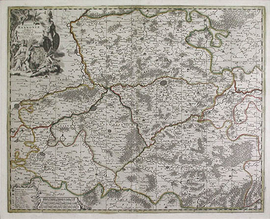
Nicolaes Visscher II also known as (Nicholas Visscher II): A large and finely detailed original engraved map, "Comitatus Hannoniae Tabula" (Province of Hainaut) dates from around 1704. It is generally held that this map is from the Visscher "Atlas minor" which was initiated by the grandfather of Nicolaes Visscher II, Claes Jansz Visscher (1587-1652). The National Library of Australia lists an impression of this map in its permanent collection and states that "Comitatus Hannoniae Tabula" is plate 81 from the "Atlas Minor". The Bibliotheque Royale de Belgique, however, also has an impression of this map and lists its genesis to a 1705 Visscher atlas entitled, "Recueil de cartes des Pays-Bas meridionaux et des Provinces-Unies". Regardless of its origin, "Comitatus Hannoniae Tabula" ('Le Comte d'Hainaut') is an impressive original example of early eighteenth century cartography. Such cities of present day southern Belgium as Mons (the capital of Hainaut), Ath, Tournai and Charleroi are engraved in detail. Also the northern French centers of Valeniciennes, CambraI and Quesnoy are represented. This map covers the area as far west as Flanders, as far east as Brabant and south to Picardy. A large and finely engraved cartouche occupies the upper left corner. Tables dealing with systems of distance and pictorial classifications of cities, towns, fortifications, cathedrals, monasteries, churches, etc., are seen to the lower left. |
| Title: | Comitatus Hannoniae Tabula 'Le Comte d'Hainaut' (Map of the Province of Hainaut) |
| Artist: | Visscher, Nicolaes II 'Nicholas' (Amsterdam, 1649 - c. 1702 - 1709) |
| Date: | c. 1704 - 1705 |
| Medium: | Original Line Engraving |
| Publisher: | Nicolaes Visscher II, Amsterdam |
| Source: | Atlas minor, sive geographia compendiosa qua orbis terrarum |
| Note: | Nicolaes (Nicholas) Visscher II was the final member of a foremost Dutch seventeenth century engraving, publishing and map making family. Claes Jansz Visscher (1587-1652) founded the family firm and was known for his work in both fine art and cartography. Engraved portraits of Charles I of England, John Calvin and Erasmus were created and published by him. The first issue of his "Atlas Minor" was published in 1664, and during the following forty years updated and revised editions appeared. He was succeeded by his son, Nicholas Visscher I (1618-1679). Upon his death, Nicolaes Visscher II assumed control and published maps into the first decade of the eighteenth century. "Comitatus Hannoniae Tabula "(Province of Hainaut) was both engraved and published by Nicolaes Visscher II. |
| After the death of Visscher (sometime around 1702 to 1709) the plates were eventually sold to Peter Schenk. He then re-issued the plates under his own name. | |
| When one examines a map such as "Comitatus Hannoniae Tabula" 'Le Comte d'Hainaut' (Map of the Province of Hainaut) it is easy to understand why the cartography of the Visscher family has always been held in high esteem. The cartouches are prominent and display artistic qualities far superior to most. Many, in fact, were etched by Gerard de Lairesse. Their maps were thus both accurate and appealing, a difficult combination to achieve. | |
| Size: | 18 1/4 X 23 3/4 (Sizes in inches are approximate, height preceding width of plate-mark or image.) |
| UnMatted | |
| Buy Now | Price: $795.00 US |
| Condition: | Printed upon early eighteenth-century, hand-made, laid paper and with full margins as published in Amsterdam around 1704. This is a strongly printed impression with full colors and in excellent condition throughout. Containing the double-page vertical fold, as always. Altogether "Comitatus Hannoniae Tabula" (Province of Hainaut) represents a prime, original example of the 17th and early 18th century map making skills of the Visscher family. |
| Subject: | Nicolaes Visscher II, (NicholasVisscher II), Claes Jansz Visscher, "Comitatus Hannoniae Tabula" (Province of Hainaut), ('Le Comte d'Hainaut') Atlas minor, original hand-colored engraving, Mons (the capital of Hainaut), Ath, Tournai and Charleroi, Gerard de Lairesse, 17th and early 18th century cartography, early Dutch map making, Valeniciennes, CambraI and Quesnoy. |
| Important Information: | The artist biographies, research and or information pertaining to all the original works of art posted on our pages has been written and designed by Greg & Connie Peters exclusively for our site, (www.artoftheprint.com). Please visit us regularly to view the latest artworks offered for sale. We will soon be posting an update of our most recent research and include the biographical and historical information pertaining to our next collection of original works of art created by artists throughout the centuries. We hope you found the information you were looking for and that it has been beneficial. Our Gallery, (Art of the Print / www.artoftheprint.com) guarantees the authenticity of every work of art we sell 100%. Full documentation and certification is provided. We offer a wide selection of international fine art dating from the early Renaissance to the contemporary art period. |
Original Line Engraving by Nicolaes Visscher II (Nicholas Visscher II).
 |
| Comitatus Hannoniae Tabula 'Le Comte d'Hainaut' (Province of Hainaut) |
| Selected Directories in our Gallery (Art of The Print / www.artoftheprint.com), with a focus on the area of interest for this original work of art. | |
| Art of the Print / www.artoftheprint.com sells international fine art. Our collection consists of original paintings, watercolors, drawings, and original prints, such as etchings, engravings, lithographs, woodcuts, silk-screens, aquatints, mezzotints, linocuts, monoprints, and other mediums of original art. All of these works of art have been created by prominent and established painters, illustrators, watercolour artists and printmakers from around the world. The art in our gallery ranges from the early Renaissance period to the modern and contemporary art period. You can view other original artworks similar to the subject under discussion on this page listed in the following art directories. | |
| Century: | |
| Old Master Artist Index | The 'Old Master' artist directory contains a selection of original works of art created by international painters, illustrators and graphic artists. These original works date from the Renaissance period to the end of the 1700's. |
| Country: | |
| Dutch & Flemish Artist Index | This directory contains a listing of original works of art created by Dutch & Flemish artists and or views of Holland or art with a Dutch theme. The artworks date from the 17th century to the 20th century. |
| Subject: | |
| Maps: Art Index | This 'Map' directory contains original 18th & 19th century works of art created by 'mapmakers' with a focus on 'Cartography - Maps' from Belgium, Germany, England, Wales, France, Italy, India and other countries. |
![]()
Customer inquiries: Contact us ![]() or
phone Greg & Connie (905) 957-6666
or
phone Greg & Connie (905) 957-6666
www.artoftheprint.com - Home | About Us | Artist Index | Gallery | Catalogue | Our Policy | Contact Us | Site Map
| © copyrighted by Art of The Print / www.artoftheprint.com / Greg & Connie Peters. All Rights Reserved. |